 NERC Data Catalogue Service
Open University
Type of resources
Topics
Keywords
Contact for the resource
Provided by
Years
Formats
Representation types
Update frequencies
-
The dataset was collected between 2016-2018. A range of different environments were sampled including urban and rural sites in the South East of England, a compost facility in the East of England and a chicken farm in the South East of England. At each site viable bioaerosols (total bacteria, gram negative bacteria and fungi), endotoxin and particulates were measured. Full details about this dataset can be found at https://doi.org/10.5285/acae99ba-b088-4544-9c48-71d70498c16f
-

This dataset consists of a spreadsheet of data and a series of photographs. A set of natural phlogopite crystals were exposed to varying partial pressures of a He-Ne-Ar gas mixture at 930-1030°C for 20-161 hours to investigate the solubility of these gases in phlogopite. The experiments and analyses were carried out in 2013 and 2014. The experiments were carried out in piston cylinder apparatus at Brown University, USA by Dr Colin Jackson and the gas concentrations measured at the Open University, UK, by Dr Clare Warren. The NERC grant is NE/J013072/1.
-

Data collected from IODP Expedition 353, Site U1446. Data represent ISM derived rainfall and runoff proxies across Termination II. Mid-depth on CCSFA scale. Two age columns derived from age models based on LR04 benthic oxygen isotope record and AICC2012 chronology. Sheet 2 include Globigerinoides ruber sensu-stricto oxygen isotope data, Mg/Ca, Mn/Ca, U/Ca and Nd/Ca Sheet 3 include discrete portable X-Ray Fluorescence data for Ti, Al, K and Rb.
-
The data are associated with a paper entitled 'Widespread tephra dispersal and ignimbrite emplacement from a subglacial volcano (Torfajökull, Iceland)' by J Moles et al. (2019). See paper for full details. Data types: major element geochemistry; trace element geochemistry; 40Ar/39Ar geochronology. Table DR9 contains EPMA data of proximal lavas and ignimbrite fiamme. Table DR10 contains EPMA data of ash shards. Table DR11 contains EPMA standard data. Table DR12 contains LA-ICP-MS data of proximal lavas and ignimbrite fiamme. Table DR13 contains LA-ICP-MS data of ash shards. Table DR14 contains LA-ICP-MS standard data (raw). Table DR15 contains LA-ICP-MS standard data (corrected). Table DR16 contains 40Ar/39Ar geochronology data.
-

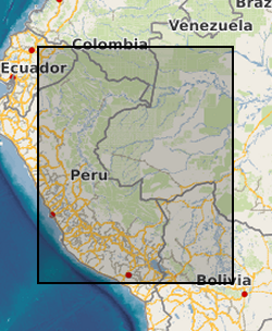
Chironomid calibration data set for tropical South America. Surface sediment samples from 59 Andean lakes across Bolivia (15 lakes), Peru (32 lakes), and Ecuador (12 lakes) over an altitudinal gradient from 150m above sea level to 4655m above sea level between 0-17 degrees South and 64-78 degrees West. Laguna Pindo is a small shallow lake on the Ecuadorian Andes (1 27.132 degrees South and 78 04.847 degrees West, 1248m above sea level). See published paper, Inferring late-Holocene climate in the Ecuadorian Andes using a chironomid-based temperature inference model by Frazer Matthews-Bird, Stephen J. Brooks, Philip B. Holden, Encarni Montoya, and William D. Gosling (2016), . Clim. Past, 12, 1263-1280, 2016. doi:10.5194/cp-12-1263-2016
-
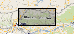
Samples of high-grade amphibolite-facies gneiss collected from north west Bhutan. Data comprises samples mineral chemistry data, U-Pb rutile data and garnet trace element compositions.
-

This dataset encompasses thin section photographs, mineral composition data and Ar/Ar data. Grant abstract: Many of the Earth's great mountain ranges, such as the Alps and the Himalaya, result from the collision between two continents. As mountains get pushed up by tectonic forces, they also get worn away by surface erosion. The uplift of topography causes long-term regional and global climate change, and conversely, changes in climate have also been linked to changes in the rate of tectonic processes. This project will define and quantify the competition between growth and erosion during the early stages of mountain uplift by exploiting a combination of state-of the art advances in numerical modelling and analytical techniques. During the early stages of continental collision, unusual (and diagnostic) rock types form under very high pressure conditions. Certain minerals in these rocks preserve details of the pressures and temperatures experienced during the journey from initial formation deep in the mantle, through their subsequent transport to the Earth's surface, their erosion, and their final deposition as sand grains in a sedimentary rock. The minerals retain distinctive chemical signatures which allows them to be distinguished from those formed in other rock types, even when eroded and turned into sand. Sand grains retain information about not only the original rock type, but also about details of the formation and transport history of the original rock. Unlocking this information will therefore yield insight into earlier stages of mountain belt growth history than is currently preserved in the bedrock record. However the methods needed to decipher these details are currently insufficiently precise to provide useful insight into changes in rates of tectonic or erosive processes, or constraints for the models. This project will therefore also develop and exploit innovative techniques for obtaining high-precision data from these high pressure rocks and their eroded remains. These data will enable the competing forces which act to shape a mountain belt during the early stages of formation to be quantified and allow the numerical models to be robustly tested. The unique contribution of this proposal lies in the combination of geodynamic numerical modelling with studies based on observational data and hence exploiting the synergy between these two, normally disparate, fields.
-
The dataset is the output of a NERC fellowship aimed to understand the long-term dynamics of tropical vegetation through palaeoecological analysis. For doing this, two sedimentary archives (Laguna Pindo and Laguna Baños) from Ecuador were radiocarbon dated and analysed for pollen, non-pollen palynomorphs, charcoal, chironomids, stable isotopes and XRF of tephra deposits. Each proxy was analysed at different resolution. Laguna Pindo is a mid-elevation lake (1250 m asl) that spans the last 50,000 years. Laguna Baños is an Andean lake located at 3800 m asl and contains sediments representative of the last 6500 years. Both water bodies are very shallow. The data is presented mainly in excel spreadsheets as raw data (except for radiocarbon dating data, which are the PDF files provided by NRCF), without any math treatment or conversion. Publication associated with NERC grant, Frazer Matthews-Bird, Stephen J. Brooks, Philip B. Holden, Encarni Montoya, and William D. Gosling (2016), Inferring late-Holocene climate in the Ecuadorian Andes using a chironomid-based temperature inference model. Clim. Past, 12, 1263-1280, 2016. doi:10.5194/cp-12-1263-2016
-
Whole-rock geochemistry data of samples collected from Tindfjallajökull volcano, south Iceland. For further information, see Moles, J. D. (2018). Volcanic archives of past glacial environments: Tindfjallajökull volcano, Iceland. PhD thesis, The Open University. http://oro.open.ac.uk/id/eprint/62117. Geographical extent: Bounding box latitude and longitude: SW corner 63°42'N 19°46'W and NE corner 63°50'N 19°28'W.
-

Analyses of volcanic glasses from a range of oceanic islands (Samoa, Cook-Australs, Iceland) and mid-ocean ridges (Reykjanes Ridge). Each glass sample was analysed for the concentrations of >60 elements, using a combination of electron probe microanalysis (EPMA), laser ablation inductively coupled plasma mass spectrometry (LA-ICP-MS) and secondary ion microprobe (SIMS) analysis. Detailed analytical techniques that were used to produce the data are presented in Wieser et al. (2020) and Reekie et al. (2019).